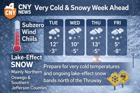
Central New York is entering a prolonged stretch of very cold weather, with temperatures remaining well below seasonal averages through the coming week. Overnight lows will frequently dip into the single digits and teens, with daytime highs struggling to climb out of the teens and 20s in many areas. Wind chills will make it feel even colder at times, especially during the overnight and early morning hours.
A persistent northwest flow off Lake Ontario will be the dominant weather feature, setting the stage for recurring lake-effect snow. While much of the region will see occasional flurries or light snow, the most impactful snowfall is expected in the long-standing lake-effect corridors.
Lake-Effect Focus Areas
The greatest snowfall potential will be across northern Oswego County and southern Jefferson County, where persistent snow bands may develop and linger for extended periods. In these areas, localized accumulations could be significant, especially where bands remain nearly stationary for several hours. Snowfall rates within the most intense bands could be heavy at times, leading to rapidly changing road conditions and reduced visibility.
Communities outside of the lake-effect zones—including the Syracuse metro area—will still feel the cold but are more likely to see intermittent flurries or light snow, rather than continuous accumulation.
Travel and Daily Impacts
The combination of cold temperatures, gusty winds, and lake-effect snow will create challenging travel conditions at times, particularly north of the Thruway and along routes closer to Lake Ontario. Even outside the heavier snow bands, icy patches may develop on untreated roads as temperatures remain well below freezing.
Residents should also be mindful of the dangers associated with prolonged cold, including frostbite and hypothermia. Exposed skin can be affected in a short period of time when wind chills drop below zero.
Looking Ahead
This cold pattern shows little sign of breaking quickly. Periodic lake-effect snow events are expected to continue through much of the week, with brief lulls possible as wind directions fluctuate. Temperatures are expected to remain below normal, keeping snow on the ground and allowing any new accumulation to persist.
CNY Community News will continue to monitor conditions and provide updates as lake-effect bands evolve and any advisories or warnings are issued.

